
City of Mission Flood and Geological Hazard Regulations
The Floodplain Management Bylaw, Fraser River Development Permit, and Geotechnical Hazards Development Permit are intended to protect people and property from flooding, landslides, and debris flow in the City of Mission.
Key Takeaways:
The following are relevant flood and geological hazard regulations in the City of Mission:
- Geotechnical Hazards Development Permit (applies to steep slope hazard areas)
- Fraser River Development Permit (applies to the Fraser River floodplain)
- Floodplain Management Bylaw (applies throughout the City)
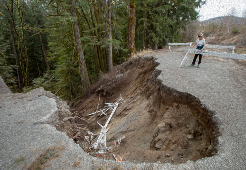
Geotechnical Hazards Development Permit
A Geotechnical Hazards Development Permit is required for development on:
- properties with slopes greater than 30%
- lands identified on Schedule 12 of the Official Community Plan (OCP)
Exemptions are detailed in Appendix D of the OCP.
A geotechnical assessment report, prepared by a professional engineer, is required for parcels in this development permit area to determine any risks from natural hazards due to geotechnical concerns. The Official Community Plan guidelines prohibit development in areas with a potential for natural hazard, unless a qualified professional provides recommendations for mitigation measures and conditions.
Fraser River Development Permit
A Fraser River Development Permit is required for development in areas identified on Schedule 11 of the Official Community Plan. Properties protected by dike are exempt, as long as requirements of the Floodplain Management Bylaw are met. Additional exemptions are detailed in Appendix D of the Official Community Plan.
An engineering study prepared by a qualified engineering professional with experience in river engineering is required for parcels in this development permit area to determine any risks from natural hazards due to flooding and any required mitigation measures.
Floodplain Management Bylaw
The Floodplain Management Bylaw regulates construction in designated floodplain areas. Floodplain setbacks and Flood Construction Levels (FCL) are outlined below. Additional regulations apply for development near alluvial fans and designated floodplain areas. Consult the bylaw for more information.

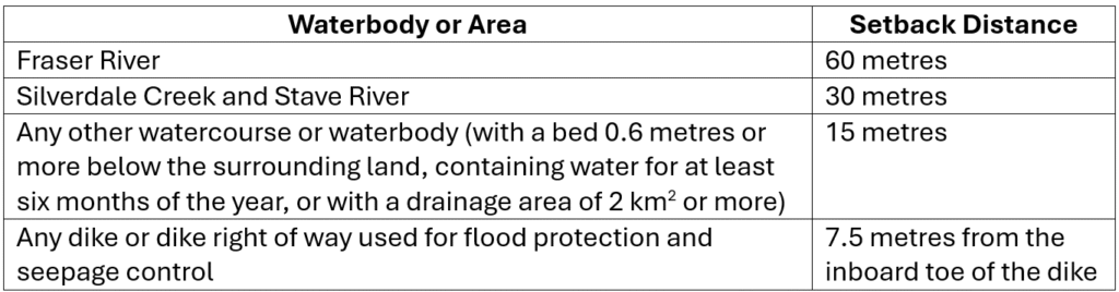
Floodplain Setbacks
The table below describes floodplain setbacks in the City of Mission. No building, structure, or habitable area can be constructed, altered, or moved within these setbacks. Minor buildings (single storey, less than 12 m2, not requiring a building permit) are exempt from these setbacks.
Flood Construction Levels
Some Flood Construction Levels (FCLs) are specified on Schedule A of the bylaw. Where it is not shown in the bylaw, the FCL is described by the following table:
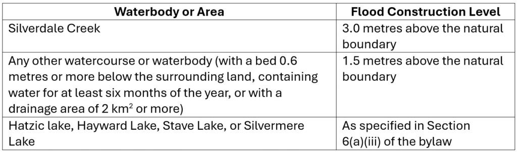
No habitable space can be constructed, altered, or moved to below the FCL. Additionally, the underside of any floor system used for dwelling, business, or storage of goods susceptible to damage by flood waters must be above the FCL. For additional works that are prohibited below the FCL, consult Section 7 of the bylaw. Exemptions to Flood Construction Levels are listed in Section 8, 9 and 10 of the bylaw. A site specific geohazard assessment report may be required prior to building permit approval.
Structural supports or landfill may be used to elevate the underside of floor systems to above the FCL, but these supports must be protected against erosion from floodwaters and other debris. Additionally, these supports shall not be extended into floodplain setback areas described above.
Disclaimer: Environmental regulations change frequently. Our goal is to keep the content of this page up-to-date and accurate. If you notice inaccurate information, please contact us so we can make corrections.
Last Updated in August 2025